Power line drone inspection: findings, waivers and records
Power line drone inspection for utility programs: what drones find, why utility FAA waivers nearly all include 107.31, and what FAC-003 asks you to keep.
A power line drone inspection flies a camera along conductors, insulators and structures, so your crews see the hardware without climbing or walking the line. The flying is the easy part. What a utility answers for is the record around each flight: which line was patrolled and when, who flew, where the crew stood, what the drone saw and what happened next.
Line work makes that record heavier, because the FAA waivers behind it nearly always cover the visual line of sight rule: 70 of the 74 utility waivers FlybyOps found on the FAA's list include 107.31. Stephen Sutton, FlybyOps' CEO, put the scale problem this way: "The challenge changes completely when you move from operating a few drones to running hundreds or potentially thousands of BVLOS flights. It becomes much less about managing an individual flight and much more about managing the entire operational system behind it."
- Drone versus ground patrol. In Georgia Power's pilot, drones found more on lines and structures than a crew on the ground, and they can't hammer-test a pole.
- Part 108. The FAA's proposed BVLOS rule treats areas within 50 feet of power lines as shielded when the owner gives permission, and it isn't final.
- The crew near the conductor. OSHA's approach distances are written for people, and we found no OSHA rule written for drones.
- The vegetation record. FAC-003 asks transmission owners for dated inspection evidence, kept for three calendar years.
What drones find on a line, and what they can't
Georgia Power's pilot program put numbers on how much more a drone sees. In the first phase, drones and ground crews inspected 1,000 structures on three lines (urban, rural and mountain), with the ground crews going second. Across the pilot, the drone team found 5,174 abnormal conditions against 1,150 from the ground-only team, and 35 critical conditions against 17. Those are company-reported totals, and the pilot wasn't a controlled test.
The same account is plain about the limits. A drone does visual inspection only. It can't hammer a pole above the groundline, which T&D World says could lead to more rejected poles. And Georgia Power surmised that crews that rely only on drones could lose familiarity with the lines, the access points and line inspection best practices.
More findings also means more to review. For the problem areas it found, the pilot's drones took about 48,000 images. Every abnormal condition found is an item someone has to rate, assign and close. The drone fills that queue. It doesn't empty it.
The common payloads are a zoom camera for hardware, a radiometric thermal camera for hot connections, and LiDAR for vegetation clearance and sag. LiDAR measures the corridor, not the hardware. As a commenter on r/UAVmapping put it, "you don't inspect powerline with LiDAR."
Published cost figures are company claims and projections, not audited costs. Georgia Power says drone inspection cuts inspection time by 40% on average and delivers cost savings of 60% against traditional methods. Xcel Energy, which in April 2018 got the first FAA authorization for a utility to routinely fly drones beyond visual line of sight over transmission lines near Denver, estimated that such flights would eventually cost $200 to $300 per mile, against an average of $1,200 to $1,600 for helicopter flights. That was a projection, and Utility Dive's caveat from the same story still applies: "those costs cannot be realized if a drone still needs a line-of-sight operator every couple of miles."
Why utility waivers center on line of sight
Part 107 makes the pilot keep the drone in view, and a power line runs on long past where anyone can see. Under 14 CFR 107.31, the remote pilot, any visual observer and the person on the controls "must be able to see the unmanned aircraft throughout the entire flight." Section 107.205 lists 107.31 among the rules the FAA can waive. Tall structures get a separate altitude allowance: 107.51(b) lets a drone fly above 400 feet if it stays within a 400-foot radius of a structure and no more than 400 feet above its top.
FlybyOps' analysis of the 2,231 waivers on the FAA's public Part 107 list in October 2026 found at least 36 electric and gas utilities holding 74 of them. Of those 74, 70 (94.6%) include 107.31, against 43.3% of the whole list (967 waivers). American Electric Power alone holds seven. We matched holders by company name, so a utility whose name doesn't give it away is missed, and the real counts are at least this high. The list shows waivers that expire on or after October 31, 2026, and it counts waivers, not pilots or flights.
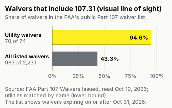
That's more than twice the rate of the list as a whole. Each of those waivers has a holder, an issue date and an expiry, and every flight under one should point back to the waiver it relied on. Our guides to building a BVLOS safety case and the wider Part 107 waiver process cover the application.
The FAA's proposed Part 108 would give line work its own path. Proposed section 108.205 treats as shielded "areas within 50 feet of powerlines and substations, railroad tracks, bridges, and pipelines, when permission from the infrastructure owner is obtained." Flights near that infrastructure without the owner's permission wouldn't qualify as shielded. The proposal was published in August 2025, and as of October 19, 2026 the final rule hasn't been published. For a contractor flying someone else's lines, that permission would become one more document to keep with each job.
Approach distance is a rule for the crew
OSHA's minimum approach distance rule protects the people working near an energized line. Under 29 CFR 1910.269(l)(3), which covers the operation and maintenance of transmission and distribution lines, the employer must ensure that "no employee approaches or takes any conductive object closer to exposed energized parts than the employer's established minimum approach distance." The construction rule, 1926.960, uses the same wording. Neither section mentions drones or aircraft, and we found no OSHA letter of interpretation that does.
The text doesn't say whether a drone counts as a conductive object. What the rule plainly reaches is your people. If a pilot, observer or ground crew member works near energized parts during a job, the approach distance your company set applies to them, and we'd keep the briefing on it with the flight.
The aircraft has its own problem near conductors. In Drexel University tests that simulated power line conditions, strong magnetic fields saturated a drone's magnetometer, and a researcher said the navigation trouble "can sometimes cause drones to crash." Compass behavior, shield wires and what to check before takeoff are covered in can you fly a drone over power lines.
What happens if a drone hits a power line
A drone that hits a power line can bring a conductor down and cut power to customers. In West Hollywood in 2015, Southern California Edison said the outage was caused by a drone that hit some power lines, "causing one of them to come down", and 187 customers lost power for about four hours. In Browns Plains, Queensland, in October 2022, a Wing delivery drone made what Wing called a "precautionary controlled landing" and "came to rest on an overhead power line". Energex restored power to about 2,000 customers within 45 minutes, and about 300 customers were left without power for three hours.
Neither was an inspection flight. On an inspection program, the same strike is tied to a specific flight, aircraft, pilot and job, and the questions after it go to that record: what the risk assessment said, where the crew stood and what the aircraft's maintenance history shows.
What FAC-003 asks a transmission owner to show
For a transmission owner, NERC's vegetation standard FAC-003-5 is the rule that names what inspection evidence looks like. It applies to overhead transmission lines at 200 kV and above, plus certain lower-voltage lines named by the Planning Coordinator or Transmission Planner or on a Major WECC Transfer Path. Distribution lines are out of scope.
Requirement R6 calls for a vegetation inspection of 100% of applicable lines at least once per calendar year, with no more than 18 calendar months between inspections on the same right of way. The evidence it gives as examples is "completed and dated work orders, dated invoices, or dated inspection records," kept for three calendar years. The standard names no inspection method, and its technical basis says vegetation inspections can be performed in conjunction with general line inspections. We read that as room for a drone patrol to serve as the R6 inspection if it covers the lines and is dated. Whether yours does is for your compliance team and your auditor to settle.
If your drone patrol is your vegetation inspection, its record has two halves, and they live in different systems.
The inspection half covers the line or circuit and span, the date, what was found, who reviewed it and the work order that followed. That lives in your inspection-data platform, and drone software for utility inspections covers where each tool fits.
The flight half shows how the patrol was flown. That's what FlybyOps holds. Tens of thousands of flights are logged on the platform each month, most of them BVLOS. For each flight it keeps:
- The job. Projects and jobs are drawn as areas on a map, and every flight, document and risk is grouped under them. Flight Sync records flights on supported DJI enterprise aircraft automatically through DJI Pilot 2, with the GPS track, altitude, speed and battery, and links each one to the project whose area covers the takeoff point. Flights on other aircraft are entered by hand, and automatic sync for other makers is planned.
- The waiver. A flight plan and its flight log can carry permits and other supporting files, such as the waiver, and documents keep their version history.
- Pilot, crew, aircraft and weather. Each flight log names the pilot and ground crew, hours roll up to the pilot and the airframe, and weather is recorded with each flight.
- The hazard and the strike. The risk register scores hazards on a SORA 5×5 grid with owners and review dates, and its feature page lists "Flying near power infrastructure" among the recurring hazards to record. Incidents are filed against a flight, job or aircraft, and admins and the relevant project managers are notified automatically.
- Contractors and edits. Five roles scope what each person sees, so a pilot sees only assigned jobs. An append-only audit log, on every plan, shows who changed a record and when.
The Business plan adds maintenance schedules, pilot currency tracking, anonymous incident reports and contractor access controls.
The flight half looks much the same on a wind turbine inspection or a cell tower inspection; the inspection half and the rule behind it change with the asset. For how one record serves the FAA, internal audit and outside regulators across a whole program, see our guide to running a utility drone inspection program.
FAQ
Which drone is best for power line inspection?
There's no single pick. Georgia Power, for one, mixes aircraft: its fleet in 2024 was 14 DJI M300s with H20T cameras, 10 DJI M30Ts and 3 Skydio X10s.
Do power line drone pilots need more than a Part 107 certificate?
The FAA requires the Part 107 remote pilot certificate for commercial flying, and some utilities add their own training on top. Southern Company, Georgia Power's parent, requires its more than 160 in-house pilots to complete extra training beyond their Part 107 certificates.
Do utilities tell customers before a drone patrol?
Some do. In 2019, PPL Electric said customers along the line got an automated call first, and that its drones focus "only on lines and related equipment, not on surrounding areas", flying on weekdays between 8 a.m. and 5 p.m.
See it in action
Bring your drone program onto one record
FlybyOps gives enterprise drone teams a single audit-grade record for projects, flights, equipment, risks and incidents. Start free — 14-day trial, no credit card.
Start free trial