Wind turbine drone inspection: rotor stop and 400 ft line
Most US wind turbines reach past 400 ft at the blade tip. What a wind turbine drone inspection covers, and what the program should write down.
A wind turbine drone inspection is a short flight around a stopped turbine that photographs the blades, tower and nacelle from outside, the external visual pass a rope-access crew would otherwise climb for. The flight around the blades is the quick part. A program gets judged on the record around it, months later, when someone questions a finding.
Four calls go into that record, and each one should be written down:
- The rotor stop. Someone orders it, someone confirms it, and someone hands the turbine back to the site.
- The altitude. On most US turbines the blade tip sits above 400 ft while the nacelle stays below it, so the program needs a written basis for flying up there.
- The wind limit. The go/no-go call is made against a number set before the crew drives out.
- What the camera can't see. The inside of the blade, bond lines and lightning down-conductor continuity need other methods.
What a drone inspection covers, and what it leaves for rope access
A camera drone covers the outside of a turbine: blade surfaces and leading edges, the tower, and the nacelle exterior. That external visual pass is the part of the job it takes over.
The speed claims disagree with each other. SkySpecs, an autonomous-drone vendor, puts a standard autonomous external blade inspection at about 15 minutes per turbine. Fly-by Guys, the drone company behind FlybyOps, says 30 to 45 minutes, and heliguy, a UK drone reseller, says under an hour against three to six hours for rope access. The per-turbine prices we found online come from vendors and state no method, so budget from your own quotes.
The inside of the blade is a different job. ENGIE Green says internal blade damage "generally requires inspection by technicians who physically get inside the blade", and recommends doing it every year. Lightning protection needs electrical contact rather than a photo. ENGIE Green uses a specialist drone that connects a cable to the blade receptor and measures the resistance to earth, then sends technicians only to the blades that look suspect. Bond lines are the third gap: a 2025 peer-reviewed review (Heo and Na) says the ultrasonic and acoustic-emission methods that find delaminations, voids and adhesive bond failures "not detectable through surface-level imaging" remain comparatively underexplored on drones.
German offshore wind shows one way to split the work. According to Deutsche Windtechnik, the BSH specification lets 50% of an offshore wind farm's turbines be inspected by drone each year, and after experts review the footage, 8% of those are also inspected by rope access. It's a German offshore specification, not a US one, but the order of work makes sense anywhere: drone first, then people on ropes where the footage points.
So the inspection plan needs a scope line: what the drone covered, what it didn't, and which method handles the rest. If the plan adds a thermal pass, its conditions belong in that line too, and our drone thermal inspection guide covers them.
Stopping the rotor: who asks, who confirms, what gets written down
A drone blade inspection starts with a stopped rotor. SkySpecs puts it plainly: "Yes, the rotor must be stopped." SkyVisor, another inspection vendor, says "Blades must be parked."
Stopping a turbine isn't always a button in the control room. SkySpecs says some turbines can't be braked from down-tower and need stopping or even pinning up-tower, and that site technician support may be needed for the pinning. SkySpecs also says its own operators generally stop and position turbines themselves. So the first decision is who does it: the site's technicians, the OEM's service crew or the drone contractor.
OSHA's wind energy page says "Wind farm employers must implement lockout/tagout procedures" and points to 29 CFR 1910.269(d) and 1910.147. The 1910.147 definition of servicing includes "inspecting", but only where the employee may be exposed to unexpected energization or startup. Neither text says whether a pilot standing on the ground counts. Check the site's own lockout procedure for the answer, and get it before the first flight.
For each turbine, write down who asked for the stop, who confirmed it, the rotor and blade position the flight plan assumed, and the time the turbine went back to the site. When the stop was a phone call, nobody can show later that the blade was still when the drone flew past it.
The wind limit and the go/no-go call
The turbine is stopped for a window, and the weather decides whether that window gets used. SkySpecs states its system operates in 15 m/s steady winds with gusts up to 18 m/s. A site's own limit may be lower. Fly-by Guys puts it more bluntly: "High winds or heavy rain can ground your drone." Part 107 adds weather minimums of its own: 3 statute miles of visibility from the control station, and 500 ft below and 2,000 ft horizontally from clouds. Put the limit in the plan, check it on site, and log the call either way, including the days the crew stood down.
Why the blade tip, not the nacelle, takes a turbine flight past 400 ft
FlybyOps' count of the USGS US Wind Turbine Database (September 2026 release) found that about three in four US wind turbines with a recorded height reach past 400 ft above ground at the blade tip: 54,196 of 72,339. The hub almost never does. Only 363 of the 72,389 turbines that have a hub height on file (0.5%) have a hub above 400 ft. A drone level with the nacelle is under the line, and the top of the blade arc is what crosses it.
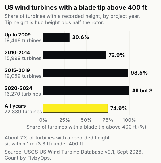
Age decides most of it. Of the turbines built up to 2009, 30.6% reach past 400 ft at the tip. The share is 72.9% for 2010 to 2014 and 98.5% for 2015 to 2019, and of the 16,270 built from 2020 to 2024, all but 3 do. If the fleet you inspect went up in the last ten years, plan every blade inspection as a flight above 400 ft.
That's why this page says "about three in four" and not a decimal. Tip height here is hub height plus half the rotor diameter, a nameplate figure rather than a measured one. About 7% of the 72,339 sit within 1 m (3.3 ft) below 400 ft, many at standard model heights, so a small error in the database moves the share. Even if you count the 5,500 turbines with no height on file as under the line, it's still 69.6%.
14 CFR 107.51(b) says the aircraft "cannot be higher than 400 feet above ground level, unless the small unmanned aircraft: (1) Is flown within a 400-foot radius of a structure; and (2) Does not fly higher than 400 feet above the structure's immediate uppermost limit." The 2016 final rule preamble says the allowance was written to enable "tower inspection and repair", the work our drone cell tower inspection guide covers, and that "This operating-ceiling provision will be waivable." Neither text mentions wind turbines, so neither says whether a turbine counts as a "structure".
So write down the basis for every flight above 400 ft: the structure allowance as the program reads it, a waiver, or both. That basis doesn't settle airspace. Under 14 CFR 107.41, a site in Class B, C or D airspace, or in the surface area of Class E airspace designated for an airport, needs prior authorization from air traffic control. Our guide to airspace authorization when LAANC isn't an option covers the manual route.
Misjudging a turbine's height has already put a drone into one. A UK AAIB bulletin describes a DJI Phantom 4 that, during an aerial survey of a sewage treatment works in Bristol in March 2020, "flew into a wind turbine, the height of which the pilot had misjudged." It wasn't a blade inspection. It's still a good reason to put the tip height in the flight plan before take-off.
Tracing a blade finding back to the flight
When an asset owner, an OEM or an insurer questions a blade finding months later, the program has to walk it back to the flight: the turbine, the pilot, the aircraft, the altitude flown, the weather and the rotor stop. Each section above ends in a record, and this is where they have to meet.
We've flown commercially as Fly-by Guys since 2018, wind turbine inspections included, and the DJI M350 is our preferred aircraft for that work. As we wrote on the Fly-by Guys blog, "implementing a drone inspection program isn't as simple as buying a drone and sending it up."
FlybyOps keeps the trail from finding to flight in one place, and operators already log tens of thousands of flights a month in it, mostly BVLOS. With Flight Sync, a connected DJI controller running DJI Pilot 2 records every flight automatically: the full GPS track, altitude, speed, battery and signal quality. The M350 RTK is on the supported list with the M300 RTK, M400, M30 and M30T, Mavic 3 Enterprise and Thermal, and Matrice 4E and 4T. Flights on other makes are entered by hand. The log shows the altitude the aircraft flew. The basis for flying there, a waiver or the program's reading of the structure allowance, goes on the flight plan as its own document.
Each synced flight is linked to the project whose area covers the takeoff point and matched to the drone in the equipment registry by serial number, so its hours land on the right airframe. Flight plans and flight logs can carry permits and risk assessments, which is where the rotor-stop permit and the record of handing the turbine back go. The risk register scores hazards such as tip height on a 5×5 severity and likelihood scale, with mitigations, owners and review dates. Incidents, near misses included, are filed against flights, jobs or aircraft, and admins and the relevant project managers are notified automatically. Weather is recorded with each flight. On every plan, an append-only audit log shows who created or changed each record. Pilot currency tracking and maintenance schedules come with the Business plan and up.
Blade analysis stays with your inspection vendor. Attach their report to the flight log it came from, and the finding and the flight sit in one record.
For the software side of a whole wind portfolio, read drone software for wind farms. A program that flies wind next to solar has the same records across more sites, covered in running a renewable energy drone inspection program. The trace is the same on a drone power line inspection, with a different set of hazards.
FAQ
Can you fly drones near wind turbines?
Yes. Inspection flights around turbines fly under Part 107, with the rotor stopped and the site's agreement. Above 400 ft, the program needs a written basis for the altitude, plus an airspace authorization where the site's airspace calls for one.
Does any of this change offshore?
Offshore, the height question gets simpler: in FlybyOps' count of the USGS database, every one of the 78 offshore US turbines with a height on record reaches past 400 ft at the tip. A testimonial on SkySpecs' page, from EDF UK's chief executive, describes 25 turbine inspections in one day at an offshore UK site, against one turbine a day by rope access before. Good practice guidelines from G+ and the Energy Institute say "the onus is on offshore wind companies to ensure that UASs are effectively incorporated into the wider safety management system".
See it in action
Bring your drone program onto one record
FlybyOps gives enterprise drone teams a single audit-grade record for projects, flights, equipment, risks and incidents. Start free — 14-day trial, no credit card.
Start free trial