Solar panel drone inspection: when to re-fly a block
Solar panel drone inspection on utility-scale sites: the sun, cloud and wind a thermal finding needs, when to re-fly a block, and what to ask a contractor.
Fly a solar panel drone inspection in strong, steady sun. The IEA PVPS recommends over 600 W/m² of irradiance, no clouds and low wind, and a module takes 5 to 15 minutes to settle after a change. On the big sites that hold three-quarters of US ground-mount capacity, holding those conditions through days of flying is the work.
So log the conditions with every block, re-fly the blocks that fell outside them, and treat each hot module as a lead for a ground check, not a verdict.
Where does US solar capacity sit, and why does site size matter?
In FlybyOps' count of the US Large-Scale Solar Photovoltaic Database (USGS and LBNL, v4.0, April 2026), 790 of 5,976 ground-mount sites have a square kilometer (247 acres) or more of array footprint. They're 13.2% of the sites, and they hold 100,162 MWac, 76.8% of the capacity. The median site has 17.2 acres of arrays. Plan the program for the 790, not the median.
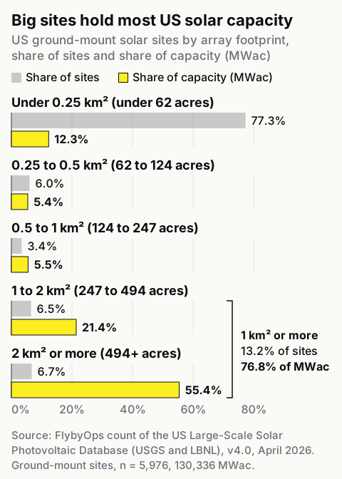
| Array footprint | Sites (share) | MWac (share) |
|---|---|---|
| Under 0.25 km² (under 62 acres) | 4,620 (77.3%) | 15,990 (12.3%) |
| 0.25 to 0.5 km² (62 to 124 acres) | 360 (6.0%) | 7,060 (5.4%) |
| 0.5 to 1 km² (124 to 247 acres) | 206 (3.4%) | 7,125 (5.5%) |
| 1 to 2 km² (247 to 494 acres) | 388 (6.5%) | 27,954 (21.4%) |
| 2 km² or more (494 acres or more) | 402 (6.7%) | 72,208 (55.4%) |
Array footprint is the database's area of panels and inverters, not the property line. The count covers the 5,976 ground-mount sites of 1 MWac and up, 130,336 MWac in all, and leaves out 635 rooftop, canopy, floating or mixed sites. The database isn't checked in the field, and its newest sites date from 2025.
The same IEA PVPS paper puts net aerial thermal imaging at 2 MWp "or even 3 MWp" an hour, depending on the detail wanted. A site of about 100 MWac carries more than 100 MWp of modules, because DC capacity runs above AC, so it needs more than 33 to 50 hours of imaging alone, before launches, battery swaps and weather holds. That's days of flying, and the sun, cloud and wind change between the first block and the last.
Distance adds launch points. 14 CFR 107.31 says that, unaided, either the remote pilot in command and the person at the controls, or a visual observer, must keep the drone in sight throughout the flight. Arrays this size rarely sit in one piece: 726 of the 790 big sites are mapped as several separate array areas. Plan a launch point per block or group of blocks and time for the crew to move between them, or get a 107.31 waiver (see BVLOS waivers and the Part 107 line of sight rules).
Most of the big sites also track the sun. In the same count, 623 of the 711 big sites labeled fixed-tilt or single-axis (87.6%) use single-axis trackers, against 43.2% of sites under 0.25 km², and LBNL reports that 99% of new utility-scale capacity chose single-axis tracking. A tracker changes the module angle all day, which the camera angle has to follow.
Which conditions make a solar thermal finding usable?
A finding is usable when the block was imaged in high, steady sun, with no cloud shadow or wind change in the minutes before, from close to straight-on to the glass, with the plant running normally. The quotes below are from the IEA PVPS review of IR and EL imaging unless a row says otherwise. For thermal work beyond solar, see our drone thermal inspection guide.
| Condition | What the source says | Log for each block | Re-fly if |
|---|---|---|---|
| Irradiance | IEA PVPS: over 600 W/m² recommended | Plane-of-array irradiance from a pyranometer or reference cell, with the time | It read under 600 W/m² in the 15 minutes before imaging |
| Clouds and reflections | IEA PVPS: "no clouds"; reflections of clouds, buildings and trees "must be avoided or minimized" | Sky cover and the time any cloud shadow crossed the block | A cloud shadow crossed it in the 15 minutes before imaging |
| Wind | IEA PVPS: "wind should be avoided because the wind adds inhomogeneous temperature fields" | Wind speed and gusts on site | Wind went over the program's written limit in the 15 minutes before imaging |
| Settling time | IEA PVPS: 5 to 15 minutes after a change | Time of the last change in sun, cloud or wind, and the time imaged | Less than 15 minutes passed between them |
| Viewing angle and tracker position | IEA PVPS: glass emissivity is typically 0.85 viewed within 90° to 60° (backsheet 0.95, within 90° to 45°) | Camera pitch, flight heading, tracker angle or mode | The camera was more than 30° off straight-on to the glass, or the tracker was stowed or out of position |
| Plant running normally | An IEA PVPS workshop talk: plant at its maximum power point, steady, free of partial shading; check soiling and clean first | Inverter status, curtailment, shading and soiling notes | The block's inverter was off or curtailed, or rows were shaded |
The last row comes from a 2021 talk by Ioannis Tsanakas of CEA-INES at an IEA PVPS Task 13 workshop, a presenter's slide rather than an IEA position.
The re-fly column is our rule. FlybyOps built it from the IEA PVPS figures, and the 15 minutes is the top of IEA's 5-to-15-minute settling range. It's strict on purpose.
The standard document for this work is IEC TS 62446-3, a technical specification whose current edition dates from 2017. IEC says it "lays down requirements for the measurement equipment, ambient conditions, inspection procedure, inspection report, personnel qualification and a matrix for thermal abnormalities as a guideline for the inspection." It sets two levels. Of the simplified inspection, the TS says "Authoritative conclusions regarding module quality are not possible with this inspection." The detailed one "may be used for periodic inspections ... and for trouble-shooting the cause of underperforming systems." Its contents include a clause on "using fast carriers for IR-camera, e.g. aerial drones" and a table of required inspection conditions. Volateq, an inspection company, says that without logged plane-of-array irradiance, ambient temperature and wind, "the result will not be IEC 62446-3 compliant," and it requires them logged at one-minute intervals or finer.
Irradiance also sets how bad a fault looks. The IEA review says "the temperature gradients on modules and arrays increase linearly with the global irradiation," so the same fault reads hotter on a brighter day. Compare severity only at similar irradiance, between blocks and between years. Sitemark, an analytics vendor, normalizes hotspot temperature differences to 1,000 W/m² so a bright day doesn't make faults look worse. Either way works only with the irradiance logged against each block.
What does a thermal drone miss on a solar farm?
A radiometric thermal camera, usually flown with an RGB camera for context, finds faults that change how a module heats up, and it misses some that don't. A controlled test at DTU, published in EPJ Photovoltaics in December 2025, flew a DJI Mavic 3T at 8 to 20 m over 43 modules that had been damaged on purpose. Cracked cells read within the range of healthy ones (36 °C to 40 °C), temperatures the authors say "make them in practice indistinguishable." Their conclusion, about electroluminescence (EL) imaging, which photographs the light a powered module gives off: "without complementary EL imaging, reliable crack diagnosis is highly uncertain."
The test found errors the other way too. Some cells with no crack visible in EL imaging still showed apparent hotspots. The authors call that "the difficulty of relying on IRT to identify cracks without risking false positives," IRT being infrared thermography. And early potential-induced degradation (PID) "may go unnoticed in field IRT inspections."
Other faults stayed easy to see. Shorted bypass diodes and heavy soiling were still detectable at an irradiance as low as 200 W/m². Flying higher read soiling hotspots about 5 to 10 °C cooler, but the authors found the altitude effect "generally negligible compared to irradiance effects." That's no reason to fly in weak sun: a diode found at 200 W/m² still can't be graded against one found at 800.
For module quality across a site, the IEA review gives a rule of thumb: "thermal abnormalities of less than 10 % of the recorded modules do not indicate a special quality issue regarding the used modules." Above 10%, it says, look into why. That's a test of the module batch, not a sign that each hot module is fine to leave. The review also warns that "a missed fault diagnosis, either as non-detected fault or as 'false alarm' may lead to wrong performance assessment and maintenance decisions."
So treat the thermal report as a screen, and treat each hot module as a lead. Send a technician to check it on the ground, with EL or an IV curve (an electrical test of the module) where the fault type calls for one, and attach the result to the finding before it goes into a warranty claim. For a claim against a module maker, the IEA review says EL images taken before installation "could be very useful in case of legal actions against producers."
What to ask a solar inspection contractor for
Put these in the scope of work, in writing, before the first flight:
- The inspection level. Simplified or detailed under IEC TS 62446-3, not just "to IEC 62446-3."
- A conditions log for every block. The table above, filled in: plane-of-array irradiance, wind, cloud and the time imaged, against the block ID.
- The re-fly rule. Ours or the contractor's, agreed up front, including who pays for a re-flight.
- Raw radiometric files. The image files with a temperature in every pixel, not only the report's screenshots, so another analyst can read them again next year.
- A named analyst. The IEA review says "As orientation for personal qualification, the ISO 9712 Level 2 can be named, as also described in IEC 62446-3 TS Ed.1."
- Findings tied to module and string IDs. Each with its image, the irradiance it was imaged at, and a place for the ground-check result.
- The flight record. Pilot, aircraft, dates, and the waiver behind any flight beyond line of sight.
Fly-by Guys, the team behind FlybyOps, have flown commercial inspections, solar among them, since 2018. In FlybyOps, you keep the conditions log on the flight record. Each flight log records the date and time, pilot in command, aircraft, location, mission and weather conditions, and is connected to its project and equipment. Custom fields add the block ID and the plane-of-array reading from the program's own pyranometer or reference cell. Flight plans and flight logs carry attached permits, risk assessments and reports, the contractor's thermal report included. Flights on supported DJI aircraft, the Mavic 3 Thermal and Matrice 4T among them, are logged automatically through DJI Pilot 2 with Flight Sync, and flights on other makes are entered by hand. Incidents are filed against the flight, and an append-only audit log records operational activity and sensitive changes. When a finding goes into a warranty claim or gets compared with next year's, the block, its readings and the report are on one record.
If the program flies wind too, the turbines have their own limits, covered in wind turbine drone inspection.
FAQ
How much does a solar farm drone inspection cost?
Start with time. The IEA PVPS review puts a 4 MWp plant at about 5 to 10 hours of imaging by drone, against 15 to 20 hours with a hand-held camera, when all other factors are ideal. The price then moves with the array footprint, the inspection level, the re-flights the weather forces, and the EL or IV follow-up on flagged modules. The per-MW prices published online are vendors' own and unsourced, so budget from quotes.
How often should a solar farm be inspected by drone?
We found no federal regulation in the eCFR that sets an inspection interval for solar plants, so the interval comes from the maintenance contract, warranty terms, insurers or state rules. The IEC TS says its detailed inspection "may be used for periodic inspections" without fixing a period. The 2021 IEA PVPS workshop talk above recommended "Bi-annual (at least)" inspections for intermittent faults, one presenter's view. Pick an interval and write it into the program's policy. Here's how renewable operators set inspection cadence.
See it in action
Bring your drone program onto one record
FlybyOps gives enterprise drone teams a single audit-grade record for projects, flights, equipment, risks and incidents. Start free — 14-day trial, no credit card.
Start free trial